
FAA NOTAM System Contributes to Fatal Helicopter Accident in Arizona.
Would you have hit the wire?
On January 2, 2026, a professional pilot and 3 passengers were killed in Arizona when their MD530 helicopter struck a wire on a sightseeing flight. However, even just 2 days since the accident, it is clear that this accident is far different from the wire-strike accidents we are used to seeing in the helicopter industry.
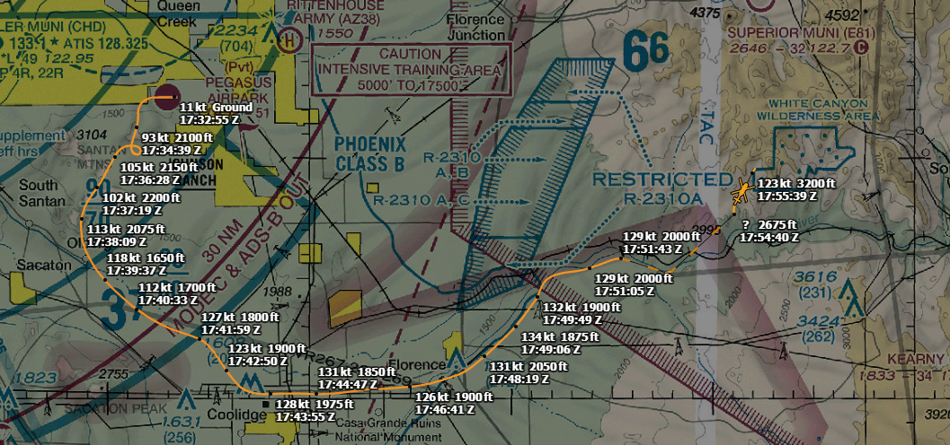
The wire struck was a 'slackline', specifically a high slackline. A high slackline allows enthusiasts to balance on a line in a similar fashion to a tight-rope walker for sport. In this case, a line was strung over a canyon in Arizona, about 45 miles ESE of Phoenix. This low-level canyon route was one familiar to the pilot. While at this time it is unclear exactly the altitude he struck the wire, ADSB data suggests he may have been as high as 500-700 feet AGL. This is corroborated by the NOTAM for the wire (more on that later) which states that the wire is at 600AGL.
Helicopter pilots are no strangers to the low level environment. There are whole classes devoted to the topic. While we can never totally eliminate the risk of flying low-level, there are certainly many things we can do to mitigate the risk. One of the primary mitigations we can take is to be familiar with the areas we operate low-level in. In this case, the pilot had flown this route many times before, and likely didn't expect there to be sudden new obstacles to his path. It also seems that while he was flying below the altitude of ridgelines to the sides of him, he may have been over 500 ft AGL, the oft-quoted start of the 'low level environment' that we try to stay out of.
So if the pilot flew at a relatively high altitude along a known-safe route and still hit a wire, what could've potentially saved him? The NOTAM issued for the wire.
Hobbyists who put up the line did report the line to the FAA, who issued a NOTAM for the line:
PRC 12/234 E81 OBST TIGHT ROPE WI AN AREA DEFINED AS 1NM RADIUS OF 331412N1110714W (3NM S E81) 2800FT (600FT AGL) FLAGGED AND LGTD 2512261400-2601060200
And a quick note on those hobbyists too: I feel really bad for them. They did the right thing. They knew that the wire they were putting up would potentially be a risk, so they reported it to the proper channels. I don't fault them for this accident at all.
The problem, however, is that the FAA NOTAM system is notoriously difficult to understand and has significant 'information overload' when used to try and plan flights. This NOTAM, for example, only has E81, Superior Municipal Airport, as a facility designator. That means unless the pilot specifically searched for NOTAMs for E81 or did some kind of route-NOTAM search, he would've completely missed it. If you search the FAA system for NOTAMs from his nearby departure airport, a private airport, you yield no results:
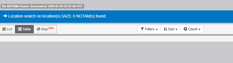
In order to get this NOTAM to show up in the FAA system, you'd have to input the Airport along his route, E81, into the search directly, or you'd have to use the 'route' plan function. Now, what would YOU type into the route planning option in order to accurately describe this route?
This planner clearly doesn't work for any kind of routing that doesn't follow strict waypoint-to-waypoint navigation. So what other tools do we have at our disposal? Foreflight! Might I remind you first, that Foreflight is not an FAA-approved source of getting NOTAMs or TFRs, so technically we'd still need to call flight service or check the FAA site to CYA here, but this is definitely easier to work with:
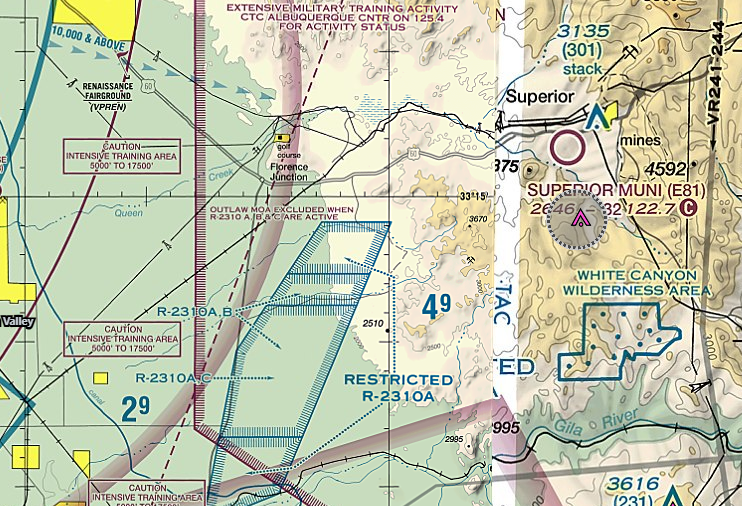
And there it is. The small gray circle just below E81 is the NOTAM for the wire. Now, had the pilot used this 3rd party app to check NOTAMs, he may have been saved.
But...we still run into issues stemming from the NOTAM system as a whole, even if we look at 3rd party sources like Foreflight. This kind of thing look familiar to you?
Welcome to the Jungle! When the NOTAM system is constantly filled with so many things that are not necessary to pilot's day-to-day operations, it immediately gets messy and hard to plan around. What's more 'fun' about this situation too, is that you must realize that every single one of these NOTAMs' graphical depictions are automatically generated by Foreflight based on the official NOTAM's text. Usually it gets things correct, as it will easily pickup on the correct location when the text says something like 'An area defined as a 3.1NM radius of <LAT/LONG>', but sometimes that isn't how NOTAMs are worded, especially with 'Military' NOTAMs.
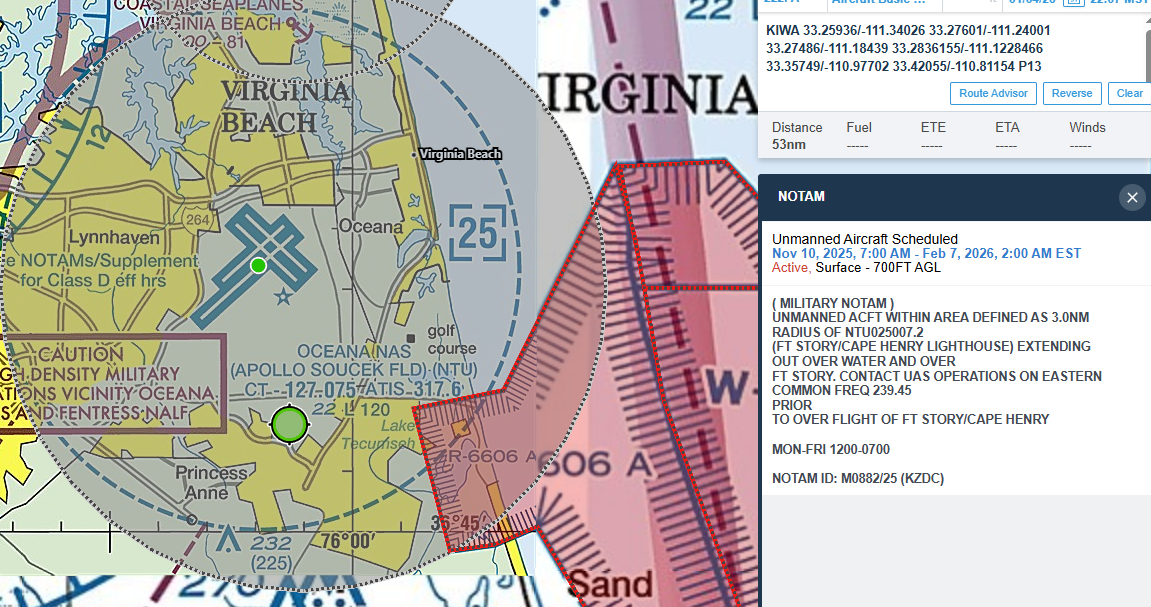
Here's an example of a military NOTAM issued for a 3 mile radius of the Fort Story lighthouse (about 5.5 miles North of NTU). However, since the Military NOTAM text is different than civilian, Foreflight doesn't recognize its location properly and just displays a 5 mile ring centered around NTU itself. (Luckily in this case ORF has a repeat NOTAM that gets the location correct for Foreflight to display.) This same location issue often comes up with parachute operations too, with NOTAMs issued around the base airport, but not the dropzone itself.
And remember how I said that Foreflight bases it's locations on the NOTAM text for lat/long...?
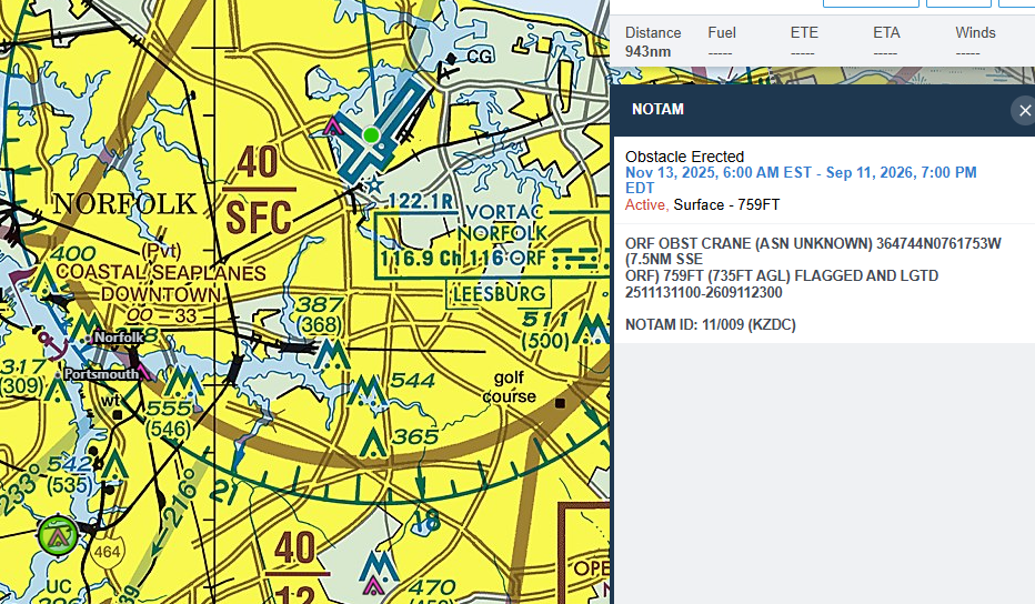
...well it's a good thing they do, because while the lat/long for this erected Obstacle is correct, the human readable description "7.5NM SSE ORF" is absolutely not. So Foreflight displays the obstacle icon correctly (since none is charted on the sectional), but notice this obstacle sits Southwest, NOT South-South-East of ORF like the NOTAM text actually reads. Funnily enough too, I only know this to be wrong because I know exactly the structure being constructed, having flown to the job site multiple times. Knowing it otherwise would actually be impossible, because the crane the NOTAM is talking about doesn't even exist yet. If you fly to this area, you'll find no-such 735ft AGL crane. So every time I fly over this spot I only know there is a potential crane in the area, but it has yet to appear in the 4 months the NOTAM has been active. I hope I actually remember this NOTAM the day the crane does decide to appear.
While on the topic of "NOTAMs I deal with on a daily basis", more military NOTAMs:
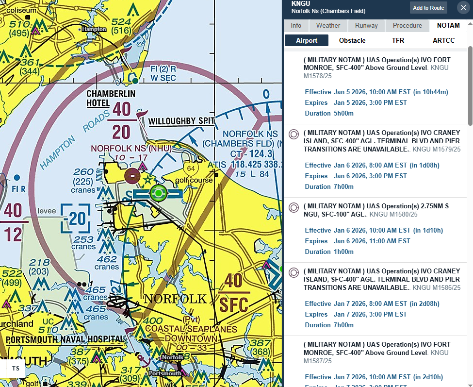
Here's an example where multiple military NOTAMs for drone operations aren't shown graphically at all! The only way you'd know about them would be if you selected KNTU and checked the NOTAMs tab. And why, you might be wondering, would you ever need to be checking NOTAMs at an airport you'd never be landing at?
Ah, and if you think the NOTAM system only has issues in the low-level environment, think again!
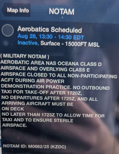
This military NOTAM closes the airspace from the surface to 15,000ft above KNTU while an aerobatic demonstration happens. Mind you, this is not a TFR, but just a military NOTAM for NTU. If you were flying direct from Miami to Newark at 14,000 feet, you'd violate this NOTAM, and probably scare the crap out of an F-18 pilot. Who during their flight planning would be checking NOTAMs for every single airport along their entire route of flight? Especially at high altitude!
How about very general NOTAMs as well?
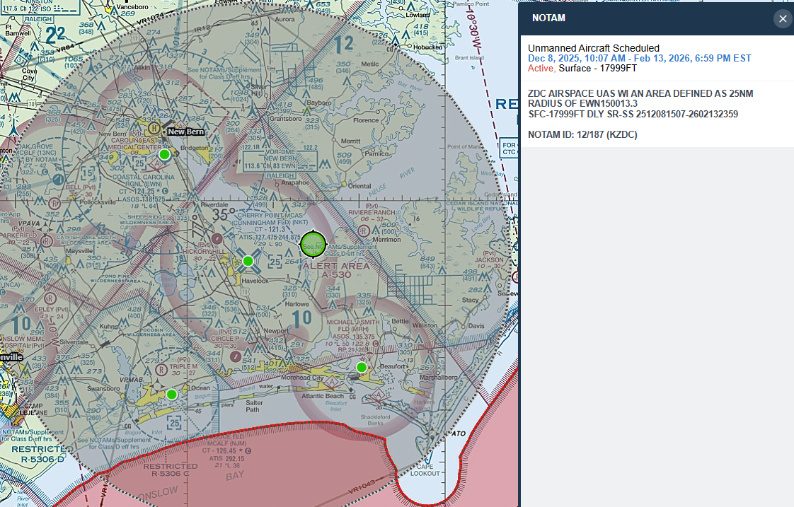
Take this NOTAM near Cherry Point for example. UAS operating during all daylight hours, in this 50-mile-across ring, from the surface to 17,999 ft...very helpful!
And for the 'big airport' folks, one of the biggest complaints of NOTAMs: The fodder.
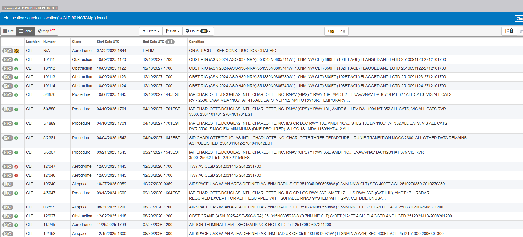
At any big airport, the list of NOTAMs is so long and full of next-to-worthless things that it makes sorting into usable information nearly impossible. CLT returns 80 results. LAX, 85. EWR, 126 NOTAMS! That's 126 vague, barely english reports that you technically would need to read before landing at EWR. Hope you've got Foreflight or some other tool to help you with that. Fun fact, if you plan a flight from EWR to JFK (an 18 mile route if you bribed the controllers to let you fly direct), the FAA system returns 374 NOTAMs that you should read. Good luck!
The big takeaway here should be that the current NOTAM system does not have your back. We as pilots have to take the final responsibility for our planning. While it is easy to whine and complain here about the system and hope it gets better, we have to live with the way it is currently.
And just to be crystal clear: I'm not saying the NOTAM system caused this accident. Low-level flying will always be risky, no matter how well-informed the pilot is. The easiest mitigation is to fly higher. However, what I am saying is that a better NOTAM system could've saved these 4 lives, while making the rest of our daily lives a whole lot easier and safer.
Looking at this accident specifically was a bit eye-opening for me. I think of all the times I go out for a photo flight, tour flight, training, etc and simply rely on the graphical representation on Foreflight and/or the NOTAM list for the aiports I'm taking off and landing from. Had there been a NOTAM for a new wire in my area, would I have caught it, or would I have ended up just as unlucky as this flight in Arizona? I hope I never have to find out.
Mitchell Hynes
Chief Helicopter Instructor, Hampton Roads Helicopters
President, Virginia Helicopter Association